

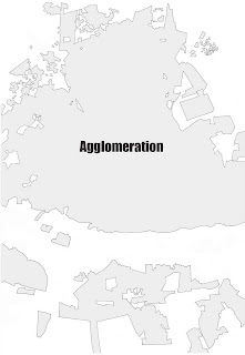
Agglomeration
The urbanisation Greater Johannesburg Region is rapidly sprawling towards north, Pretoria. The city edge is demarcated by the fragmented enclaves in the landscape.

The urbanisation Greater Johannesburg Region is rapidly sprawling towards north, Pretoria. The city edge is demarcated by the fragmented enclaves in the landscape.

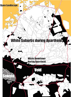
Void and Naming
Mining belt and industrial area, Witwatersrand (White Water Ridge), to south of downtown Johannesburg is the ready-made buffer zone, stretching more than 120 km, separating the city centre and northern suburbs from southern townships. This mining belt is what generated Johannesburg’s early urbanisation.
In general, names of places refer to European or American places, such as Hyde Park, Orlando, Beverley or Melrose Estate. In townships, some areas are simply named as zone 1, or zone 2 etc.

Zones
CIAM’s zoning principles were fully exploited to the utmost potential for racial segregation: white town, black town, industry and buffer zones - engineered enclaves. Johannesburg is a landscape of zones and voids. Zones are reserved for mono-racial, mono-functional, mono-mind-set; voids are buffers separating different zones.
CIAM’s zoning principles were fully exploited to the utmost potential for racial segregation: white town, black town, industry and buffer zones - engineered enclaves. Johannesburg is a landscape of zones and voids. Zones are reserved for mono-racial, mono-functional, mono-mind-set; voids are buffers separating different zones.

Districts
Downtown: the grid iron plan represents hypocritical universality
Suburbs: northern suburb is a mosaic of enclaves, each with slightly different characteristics, but overall is a monotonous social landscape. In some districts infrastructures are already laid out and names of the districts already appear on the map before building construction takes place, in sharp contrast with the shortage of basic infrastructure in the (nameless) townships.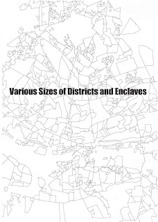

